The Guana Tolomato Matanzas Research Reserve stretches roughly 40 miles down Florida's northeast coast, from Ponte Vedra Beach south to the Marineland boundary, spanning nearly the full length of the Heritage Crossroads Corridor. At more than 73,000 acres across St. Johns and Flagler counties, it ranks among the largest in NOAA's 30-site National Estuarine Research Reserve System. Yet most visitors who know the GTM Reserve know only one end of it - the visitor center near Ponte Vedra - while the Flagler County sector at Marineland sits largely unvisited and unwritten about. This guide covers both access points, the three rivers that give the reserve its name, and the working research mission that operates quietly alongside every hike and birding session.
What the GTM Reserve Is
The GTM Reserve wears two identities that rarely appear on the same property. It is a free, public day-use recreation area where anyone can walk, bird, paddle, and swim. It is also an active NOAA research station generating continuous estuarine data that feeds national environmental databases. Those two functions run in parallel on the same land, and understanding both changes how you see the place.
Florida acquired land for the northern component in 1984 through the Conservation and Recreation Lands program, more than a decade before federal designation. NOAA added the GTM to its National Estuarine Research Reserve System in 1999, creating a formal partnership between state land management and federal science. The result is a reserve governed jointly by the Florida Department of Environmental Protection and NOAA - an arrangement that funds both the trail maintenance you walk on and the water sensors you cannot see.
The corridor connection is literal. Pull up a map of the Heritage Crossroads region and draw a vertical line from Ponte Vedra to Marineland along A1A and the Intracoastal. The GTM Reserve fills almost everything to the west and east of that line - a green and blue corridor that most people drive past without realizing they are inside it.
The Three Rivers and Their Names
The reserve's full name encodes a compressed history of the people who shaped this landscape. Each river carries a different era.
The Guana River is the northernmost. Its name is believed to derive from the Timucua people who inhabited this coast for thousands of years before European contact. Today the Guana is partly artificial - a water control project between 1957 and 1962 dammed the river and installed structures to create Lake Ponte Vedra, enhancing waterfowl habitat. The result is a nearly 10,000-acre wildlife management area centered on that lake, now one of the premier birding sites on Florida's Atlantic coast.
The Tolomato River runs through the middle section. Timucuan shell middens line its banks, physical evidence of communities that harvested oysters and fish from these waters for generations. When the French expedition of 1564 passed through, Jacques Le Moyne de Morgues drew the Timucua people, making the Tolomato corridor one of the earliest documented landscapes in North America. That history sits beneath the reserve today - sometimes literally, in the shell and refuse layers that archaeologists read like a slow archive.
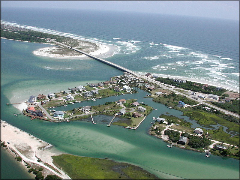
The Matanzas River takes its name from a Spanish word for slaughter, marking the 1565 massacre of French Huguenots near its inlet by Spanish forces under Pedro Menendez de Aviles. The Matanzas is tidal, influenced by two inlets and carrying a significant tidal range that swings noticeably on a strong moon. Matanzas Inlet itself is one of the few remaining natural, undredged tidal inlets on Florida's northeast coast - a rare thing along a coastline that has been straightened, channeled, and stabilized almost everywhere else.
Northern Component: The Guana River Area
The northern visitor center near Ponte Vedra Beach is the reserve's most developed entry point. Entry to the visitor center building is free. A vehicle access fee applies to reach the managed recreation areas beyond it - check gtmnerr.org for the current rate. The facility is open daily except state holidays; hours are posted on the official site.
Inside, the visitor center holds aquaria stocked with live local marine species, an audiovisual theater, and natural and cultural history exhibits. An interactive scavenger hunt is designed for K-8 visitors, making this one of the few professionally staffed, free nature education facilities on the entire Heritage Crossroads Corridor. Families without a reservation for a guided program can still engage seriously with the material through the self-guided exhibits.
The recreation area behind the visitor center opens into the Guana River Wildlife Management Area. The terrain includes more than 10 miles of trails through coastal scrub, maritime hammock, and marsh edges, with additional beach boardwalks reaching the Atlantic. Mountain biking is permitted on designated trails. A viewing tower on Capo Creek gives one of the widest panoramas of salt marsh available from dry land on this stretch of coast - a low, open sweep of grass and water that reads completely differently at high tide than at low.
Lake Ponte Vedra is the birdwatcher's main draw. Thousands of migratory waterfowl winter here, using the managed lake as a staging and foraging area during Atlantic Flyway migration. Birders have recorded more than 220 species at the wildlife management area alone. The artificial lake that might seem like an intrusion turns out to be the feature that brings the birds.
Southern Component: Marineland and the Flagler County Sector
The GTM Reserve's southern field office sits on A1A in Marineland, just north of the Flagler County line. This is the access point almost nobody writes about, and it anchors a part of the reserve that feels completely different from the Ponte Vedra end.
Adjacent to the field office is the River-to-Sea Preserve, roughly 90 acres owned jointly by Flagler County and the Town of Marineland. A trail just over a mile long runs from the Matanzas River side through a coastal hammock to the Atlantic beach - a rare walk that takes you from the Intracoastal to the ocean entirely on foot through protected land. The hammock is thick with live oak and cabbage palm, shading a trail that stays cool even in summer.
Matanzas Inlet marks the reserve's southern boundary and is worth understanding before you arrive. Unlike nearly every other inlet on this coast, it has not been dredged or channelized to the degree that most Florida inlets have been. The inlet migrates, shoals, and reshapes itself on seasonal and storm-driven timescales. That instability is exactly what makes it ecologically rich - shifting sandbars support nesting least terns and Wilson's plovers, and the tidal exchange drives high productivity in the surrounding marsh. Stand at the inlet's edge on an outgoing tide and you can watch the current carry plankton, juvenile fish, and floating material seaward: the reserve's food web on display.
Two heritage sites sit within close range of the Marineland field office. Fort Matanzas National Monument, a few miles south, is the tabby coquina outpost the Spanish built in 1742 to guard the back channel into St. Augustine. The coquina that fort is made from - compressed shell and coral from ancient dunes - outcrops throughout the GTM Reserve's shoreline and is part of the same geological formation that supplied stone for the Castillo de San Marcos. The GTM's oyster bars and coquina ledges are not just habitat; they are the living end of a geological story that also produced two of the corridor's major heritage landmarks.
Wildlife and Habitats
A species inventory for the Guana River Marsh Aquatic Preserve documented the scope of what lives within the reserve. The numbers are large: more than 40 mammal species, more than 350 birds, over 40 reptile species, more than 20 amphibians, roughly 300 fish species, and close to 600 plant species. The reserve's habitats are classified as essential to dozens of state or federally protected animal species and several protected plant species.
The habitat range explains those totals. Within the reserve you move through:
- Salt marsh - the dominant habitat, producing organic material that supports the entire estuarine food chain
- Oyster bars and tidal creeks - filtering water and providing structured habitat for juvenile fish and invertebrates
- Coastal scrub - a fire-dependent upland community supporting gopher tortoises, Florida scrub-jays, and rare endemic plants
- Maritime hammock - dense broadleaf forest immediately behind the dune line, sheltering migrating songbirds in spring and fall
- Open beach and dune systems - nesting habitat for loggerhead sea turtles and several shorebird species
The Atlantic Flyway runs directly over the reserve. During fall migration, the hammocks fill with warblers, vireos, and thrushes moving south. Winter brings diving ducks and dabbling waterfowl to Lake Ponte Vedra in concentrations that reward an early start. Spring activates shorebird activity at Matanzas Inlet. Sea turtle nesting runs through summer on the Atlantic beach.
The Research Mission and SWMP
NOAA's System-Wide Monitoring Program runs at every National Estuarine Research Reserve, and the GTM's installation is one of its more comprehensive. The program deploys electronic water-quality loggers at fixed stations throughout the reserve's estuarine system. These instruments measure salinity, dissolved oxygen, temperature, pH, turbidity, and water depth continuously - generating a data record that researchers can query across years and decades to detect estuarine change.
The data are publicly available through NOAA's SWMP data portal. That matters practically: if you want to understand whether the salinity regime in the Tolomato River has shifted over the past decade, or how dissolved oxygen drops during summer low-water events, the answer is in a downloadable dataset that any researcher or informed citizen can examine.
The reserve's continuous monitoring network makes the GTM one of the few places on Florida's Atlantic coast where long-term estuarine change is tracked with the rigor needed to separate natural variability from human-caused trends.
Beyond the sensor network, the reserve runs volunteer citizen science programs that visitors can actually join. These are not cleanup events - they are structured monitoring protocols where your data enters a permanent record used in published research:
- Butterfly transect monitoring - standardized counts along fixed routes that track population trends over time
- Nesting shorebird surveys - documenting where least terns, Wilson's plovers, and American oystercatchers nest along the beach
- Plankton counts - collecting and identifying microscopic organisms at fixed stations to track seasonal and long-term change
- Sea turtle nesting documentation - tagging nests, recording crawls, and collecting hatching success data on the reserve's Atlantic beach
Contact the GTM Reserve through gtmnerr.org to ask about current volunteer schedules and training requirements for each program.
Guided Programs and Education
The GTM Reserve runs free guided programs from the Marineland field office. Two recurring offerings address the southern component's ecology and history directly. The River-to-Sea Trail Walk leads participants through the coastal hammock, covering plant identification, dune formation, and the land's layered cultural history from Timucuan use through Spanish occupation to modern conservation. The Matanzas Inlet Interpretive Hike focuses on the inlet itself - how natural tidal inlets form and migrate, how coquina is created and erodes, and how to identify nesting shorebirds by behavior and habitat preference. Both programs run on a reservation basis; check the GTM Reserve's events calendar for dates and to book a spot, since programs fill.
The northern visitor center near Ponte Vedra functions as the indoor education complement to those field programs. Its aquaria hold live specimens of the same species found in the adjacent estuary - flounder, juvenile fish, and invertebrates that are easier to examine here than in murky tidal water where the same animals disappear against the bottom.
Planning Your Visit
Two Access Points, One Reserve
Most visitors will do better to plan separate days for the northern and southern ends rather than trying to cover both at once. The Guana River area near Ponte Vedra is a full half-day on its own if you want to walk trails and bird the lake. The Marineland sector pairs well with Fort Matanzas National Monument a few miles south and the Marineland Oceanarium across the street.
| Feature | Northern - Ponte Vedra | Southern - Marineland |
|---|---|---|
| Visitor center | Full center, aquaria, theater, exhibits | Field office only |
| Trail character | Scrub, marsh edge, beach boardwalk, longer network | Coastal hammock and beach, shorter route |
| Primary birding draw | Wintering waterfowl, marsh panoramas | Inlet shorebirds, hammock migrants |
| Vehicle access fee | Yes - check gtmnerr.org for current rate | None at River-to-Sea Preserve |
| Nearby heritage sites | Timucuan midden corridor, Tolomato River | Fort Matanzas, Marineland Oceanarium, coquina outcrops |
Water Access and Conditions
Kayak launch points in the northern component give paddlers access to the Guana River and connected tidal creeks. The Matanzas River along the southern component is also paddleable, though the open stretch near the inlet can be rough on windy days. Tidal timing matters throughout the reserve - plan to paddle with the current rather than against it.
Best Seasons
Fall brings migrating songbirds through the hammocks and shorebirds to the beaches. Winter is the peak season for waterfowl on Lake Ponte Vedra and offers the most comfortable hiking temperatures. Spring activates shorebird breeding activity at Matanzas Inlet and wildflowers in the scrub. Summer is hot and humid with afternoon thunderstorms - plan to be off exposed beach by midday and stay hydrated. Sea turtle nesting runs through summer on the Atlantic beach for those interested in the volunteer monitoring program.
Building a Full Heritage Crossroads Day
- Start at the GTM northern visitor center near Ponte Vedra for the exhibits and a morning walk to the Capo Creek viewing tower before heat and crowds build.
- Drive south on A1A through Vilano Beach, watching where the Tolomato River runs parallel to the road - you are tracking one of the earliest documented landscapes in North America.
- Stop at Fort Matanzas National Monument to see the coquina construction that connects directly to the reserve's geology and Spanish colonial history.
- Continue to the Marineland GTM field office and walk the River-to-Sea trail to the Atlantic side of the preserve.
- At low tide, examine the coquina outcrops on the beach near Marineland - the same rock type, formed the same way, as the walls of the Castillo de San Marcos.
The full drive covers the 40-mile length of the reserve and ties the corridor's natural and colonial history into a single readable landscape rather than a series of disconnected stops.
Frequently Asked Questions
Is the GTM Reserve the same as the Guana River Wildlife Management Area?
No - the Guana River Wildlife Management Area is the managed hunting and wildlife recreation area within the larger GTM Reserve, covering nearly 10,000 acres in the northern component. The GTM Reserve totals more than 73,000 acres across multiple land units, water bodies, and two counties. The WMA is what most visitors enter when they pay the vehicle access fee at the northern entrance.
Can I visit the Marineland GTM field office without a reservation?
You can walk the River-to-Sea Preserve trail without a reservation - the trail is accessible during daylight hours and no fee is charged at this access point. The free guided programs departing from the field office require advance reservations and run on a fixed schedule. Check the GTM Reserve's official events calendar at gtmnerr.org for upcoming dates before you plan a trip around a specific program.
Why is Matanzas Inlet significant compared to other Florida inlets?
Most inlets along Florida's northeast coast have been dredged, jetted, and stabilized to support navigation. Matanzas Inlet has not been altered to that degree, which means it still migrates and shifts naturally in response to storms and tidal forces. That makes it ecologically richer than engineered inlets - shifting sandbars host nesting shorebirds, the tidal exchange is vigorous, and the inlet functions as a natural nursery and export zone for estuarine species.
How do I access the water-quality data the reserve collects?
The System-Wide Monitoring Program data are publicly available through NOAA's SWMP data portal, accessible from the national NERR system website. Data can be downloaded in tabular format and include continuous readings of salinity, temperature, dissolved oxygen, pH, turbidity, and water depth. The GTM Reserve's site at gtmnerr.org also links to current data and background on individual monitoring stations.
Are there ways to contribute to reserve research without formal volunteer training?
The GTM's citizen science programs - butterfly transects, shorebird surveys, plankton counts, and sea turtle nesting documentation - each have their own training requirements, but most are accessible to motivated members of the public rather than limited to professional scientists. Contact the reserve through gtmnerr.org to ask which programs are currently recruiting and what preparation each one requires. The reserve also accepts observations submitted through standard platforms like eBird and iNaturalist, which contribute to the broader data record even outside formal programs.