Stand on the shore at Washington Oaks Gardens State Park at low tide and you can put your hand on stone that Spanish soldiers mortared into a fort four centuries ago, that plantation laborers floated downriver on rafts to build a sugar mill, and that New Deal workers shaped into a public bandshell during the Depression. The Heritage Crossroads corridor - spanning Flagler, St. Johns, and Volusia counties along Florida's northeast Atlantic coast - sits at the center of the Anastasia Formation, the ancient shellstone deposit that runs nearly the full length of the state's eastern edge. Flagler County holds more exposed coquina at the surface than any other county in that range, and the corridor gives visitors five distinct places to encounter this same stone in nature, in ruins, and in buildings still in use today.
What Coquina Actually Is
The word "coquina" is Spanish for "cockle," and the name is a geological description: the rock is made almost entirely of shells. Its primary ingredient is Donax variabilis, a small burrowing clam roughly the size of a thumbnail that lives in the surf zone. Walk the corridor beaches today and you will find them alive under your feet at the waterline - the same animal that built the ancient formations you see in the outcrops behind you.
The formation process required three things: enormous shell accumulations, the right chemistry, and time. Shells piled up in shallow coastal marine environments during the Late Pleistocene epoch. Geologist McNeill, writing in 1985, estimated the Anastasia Formation is between 100,000 and 130,000 years old. After deposition, slightly acidic groundwater percolated through the shell beds, dissolving calcium carbonate and re-depositing it as a binding cement. The result is a rock that looks like a compressed matrix of small shells - which is precisely what it is.
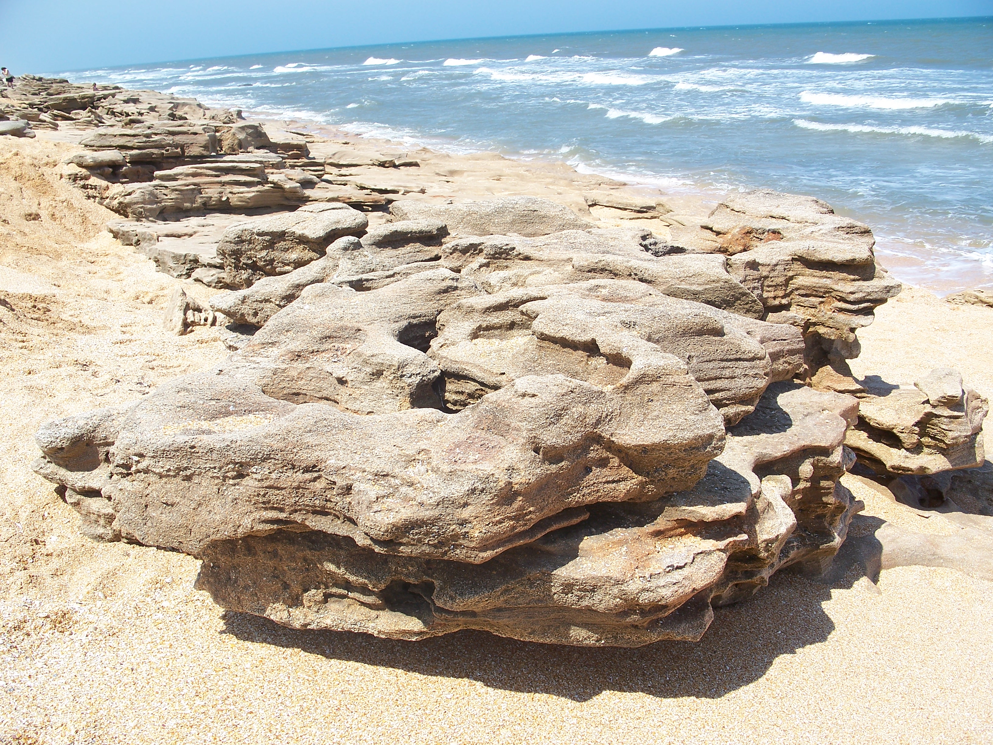
Cementation was uneven, which is why coquina varies so much from site to site. Some outcrops are dense and hard; others crumble easily. Quarried blocks could be cut with saws and chisels when fresh and hardened further after air exposure. The acidic water chemistry that built the stone continues reshaping it: rainwater pools in low spots on exposed outcrops, slowly dissolving calcium carbonate in repeated cycles and carving perfectly cylindrical holes that look almost machine-drilled. At Washington Oaks, dozens of these natural bore holes cross the flat upper rock surfaces - a process still running today.
Why Flagler County Holds Florida's Longest Exposure
The Anastasia Formation runs approximately 200 miles along Florida's Atlantic coast, from just north of St. Augustine south into Palm Beach County. Flagler County sits near the northern end of that arc and holds more coquina exposed at the surface than any other county in the formation's range.
Randazzo and Jones (1997) describe the Anastasia Formation as a "multicyclic deposit" that accumulated during several successive transgressions of the sea - not a single event, but a series of marine advances that each added new shell material to the growing deposit.Randazzo and Jones, The Geology of Florida, 1997
That multicyclic origin explains the formation's thickness and internal variation. Each marine advance deposited shells under different conditions, creating layers with different densities and cementation patterns. Where the coast has eroded or beach ridges are low, those layers surface as the rocky platforms visible along the corridor today. Flagler County's coastline geometry puts a large portion of the formation within reach of wave action and storm erosion, which continuously expose fresh coquina while burying other sections temporarily under sand.
The formation also extends significantly inland - as much as 20 miles from the present shoreline in some Florida counties, with coquina veins running parallel to the coast through the interior. That inland reach explains something critical about the corridor's history: plantation builders throughout Flagler and neighboring counties had access to local coquina without reaching the ocean. John Bulow did not need to haul stone from St. Augustine when a vein ran near his own creek.
Washington Oaks: The Corridor's Most Dramatic Outcrop
Washington Oaks Gardens State Park holds the largest Atlantic Ocean coquina outcroppings in Florida. At low tide the accessible rock stretches extensively along the shore, with geological features that elsewhere would each be a destination but here appear in concentration.
What the formations offer
- Natural arches where differential erosion cut through softer rock while harder layers above survived
- Narrow channels walkable at low tide, some wide enough for one person
- Shallow bowls in the rock surface that trap water as the tide recedes, functioning as self-contained tide pools
- Cylindrical rain-erosion holes scattered across flat upper surfaces, ranging from finger-width to wide enough to seat a coffee cup
The seasonal factor
The landscape is not fixed. Storm events can bury sections of the outcrop under feet of sand, and a beach that showed solid rock on a previous visit may look like an ordinary sandy shore after a major storm. The same storm that buries one section can scour another clean. Late winter and early spring tend to offer the best exposure, after fall and winter storms have had time to scour the beach. Summer visits after calm weather may show far less rock. The practical approach: plan around a low-tide window and accept that no two visits look alike.
River to Sea Preserve and MalaCompra: The Corridor's Other Rock Beaches
River to Sea Preserve at Marineland is a 90-acre preserve jointly owned by Flagler County and the Town of Marineland. UF/IFAS researchers have described its rocky intertidal zone as unique in Florida - a designation that travel guides consistently ignore in favor of Washington Oaks, which has a state park brand and better highway visibility. The preserve's coquina is less dramatic in scale but the intertidal ecology is richer, partly because lower foot traffic allows biological communities more room to establish.
MalaCompra Park in northern Flagler County offers a third distinct character. The sharp coquina discourages swimming, which removes the beach crowd entirely and turns the site into a geology and wildlife observation area. Shorebirds work the tide pools, and the quiet makes it the corridor's most contemplative geology stop.
- Washington Oaks: largest outcrop area, most dramatic features, highest visitor volume, full state park facilities
- River to Sea Preserve: richest intertidal ecology, lowest traffic, managed by county and municipality jointly
- MalaCompra: northernmost access point, geology and wildlife focus, no swimming
The Rock That Built St. Augustine
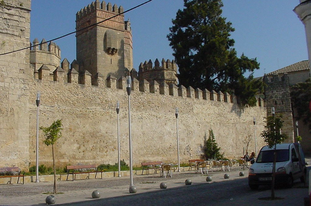
Spanish colonists identified coquina on Anastasia Island as a building material as early as 1598, decades before the city's most famous structure was begun. They quarried it continuously for more than two centuries, supplying stone for churches, homes, defensive walls, and eventually the fort still standing on the St. Augustine waterfront.
Construction of the Castillo de San Marcos began in 1672 and took nearly 25 years to complete. The labor force that cut and laid that stone was drawn from multiple populations under varying degrees of coercion:
- Members of the Guale, Timucua, and Apalache tribes, working under Spanish colonial labor obligations
- Free and enslaved Africans
- Spanish convicts assigned to construction labor
- Captured Englishmen held as prisoners
The coquina came from Anastasia Island, across Matanzas Bay - quarried, loaded onto boats, floated across, and mortared into walls by hands that appear in no monument inscription. The stone turned out to have an unexpected tactical property: rather than shattering under cannon fire, the soft coquina absorbed cannonballs, which lodged in the walls rather than fragmenting them. That was an accident of geology, not engineering. The fort has never fallen to military assault.
The Anastasia Island quarries set the template for what followed throughout the region. Once builders recognized that coquina could be sourced locally - given how far inland the formation's veins extended - the Anastasia quarries became less a unique resource and more a proof of concept.
Plantation Coquina: How Bulow and Other Corridor Landowners Quarried Locally
John Bulow ran one of the most productive sugar plantations in territorial Florida during the 1820s and 1830s, and the ruins of his sugar mill at Bulow Plantation Ruins Historic State Park are built of coquina. The question of where that stone came from has a probable answer in the corridor's geology.
Bulow is believed to have sourced coquina from a vein running near Bulow Creek and floated quarried blocks south on rafts to the plantation site. The logistics reflect how interior coquina veins made local quarrying practical: a plantation owner with creek access could quarry stone from an inland vein, load it onto flat-bottomed rafts, and move it by water - the same waterway network that moved sugar north to market moved building stone south to the mills.
The ruins at Bulow State Park today show coquina in the mill foundations and walls - stone cut, shaped, and laid by enslaved workers at the same plantation. The site connects directly to the colonial labor narrative established at the Castillo quarries: skills developed under one coercive system were transferred and applied under another.
The mill ruins also illustrate coquina's durability. Seminole raids burned the plantation structures during the Second Seminole War in 1836. The wooden buildings burned; the coquina walls did not. That same resistance to destruction - the property that made the Castillo survive cannon fire - is why stone ruins are standing while everything built of wood is gone.
The WPA Legacy: New Deal Coquina in Public Buildings
The tradition of corridor coquina for public construction carried into the twentieth century. The Daytona Beach Bandshell, built between 1936 and 1937 as a Works Progress Administration project, is constructed of coquina quarried from National Gardens in neighboring Volusia County. It is listed on the National Register of Historic Places and still in active use as a performance venue.
The WPA's choice of local coquina was partly economic - Depression-era public works drew on nearby materials to reduce costs and employ local labor - and partly a recognition that the stone carried regional identity. Using it for a public bandshell connected the structure visually to the colonial and plantation-era buildings that had used the same stone for centuries before.
The National Gardens quarry in Volusia County sits within the same Anastasia Formation that runs north through Flagler County. Geologically the stone is identical: Pleistocene shell beds, cemented by calcium carbonate, deposited during marine transgressions more than 100,000 years ago. The WPA workers who cut it were working the same formation that Spanish colonists had quarried three centuries earlier and that Bulow's laborers had floated down Bulow Creek a century before that. The Bandshell is the formation's most recent chapter in a long building history.
Living Shoreline: Ecology of the Coquina Intertidal Zone
A sandy beach is biologically sparse above the waterline. A coquina shoreline is not. The rock provides attachment surfaces, shelter, and moisture retention that sand cannot, and the intertidal zone supports a dense biological community that depends on the formation throughout its life cycle.
In the tide pools at Washington Oaks, River to Sea Preserve, and MalaCompra, regular residents include:
- Periwinkle and other snail species grazing algae from the rock surface
- Sea urchins wedged into crevices in the lower intertidal zone
- Anemones anchored to sheltered rock faces, extended when submerged
- Small fish trapped in deeper pools by the receding tide
- Algae in multiple forms, from thin crusts on dry rock to dense mats in the pools
The Donax variabilis clams that formed the rock are still present in the surf zone at the base of the outcrops - small, colorfully banded shells that burrow rapidly into wet sand as waves recede. The living animal and the ancient rock it built exist within a few feet of each other at low tide. That proximity is easy to miss if you are not looking for it, but it is one of the more arresting natural juxtapositions on any Florida beach.
The intertidal zone here is also more dynamic than rocky shorelines in many other parts of the country. Storm events rearrange the sand around and over the formations, periodically burying pools and exposing new rock surfaces. Communities that established in a buried pool may not survive a long burial event. When the rock re-emerges, ecological succession begins again. That dynamism is part of what makes the River to Sea Preserve's intertidal designation meaningful - the combination of coquina substrate, tidal range, and limited foot traffic creates conditions difficult to find elsewhere on Florida's Atlantic coast.
Visitor Guide: Planning Your Coquina Sites Visit
The single most important planning decision is tide timing. At all three beach sites, the formations are partially or fully covered at high tide. The practical window for exploring arches, walking channels, and observing tide pools is roughly two hours before and two hours after low tide. Check a NOAA tide chart for the nearest reference station before you go.
- The night before, identify a low-tide window that falls in the morning or late afternoon - light is lower, tide pool organisms are more active, and the rock surfaces are cooler.
- Arrive at Washington Oaks at least 90 minutes before low tide to explore the channels as they drain.
- Move north to MalaCompra while the Washington Oaks beach is mid-tide - MalaCompra's formations remain accessible through a wider part of the tidal cycle.
- Plan River to Sea Preserve at Marineland as a separate visit; the drive between sites takes time best spent on the rock.
- Add the Daytona Beach Bandshell or the Bulow ruins on a day when tide timing does not matter - both are inland or urban sites that can be visited any time of day in any season.
| Site | Outcrop Scale | Tide Dependence | Crowd Level | Best For |
|---|---|---|---|---|
| Washington Oaks Gardens SP | Largest on Atlantic coast | High | Higher | Geology, arches, tide pools |
| River to Sea Preserve | Moderate | High | Low | Intertidal ecology, quiet |
| MalaCompra Park | Moderate | Moderate | Low | Geology observation, shorebirds |
| Bulow Plantation Ruins SP | Built ruins only | None | Low to moderate | Plantation and labor history |
| Daytona Beach Bandshell | Built structure only | None | Varies with events | WPA architecture, historical context |
Frequently Asked Questions
Can I collect coquina rocks or shells from the corridor beach sites?
No. Collecting rocks, shells, and biological material is prohibited at Florida state parks, and county-managed preserves including River to Sea Preserve and MalaCompra Park carry the same restrictions. The formations are protected natural resources. Even small-scale collection contributes to erosion of features that took hundreds of thousands of years to form.
How do I find the low-tide window for a specific visit date?
NOAA's tides and currents website publishes daily tide predictions for reference stations along Florida's northeast coast. Search for the station nearest to your target site. Tide times shift by roughly 50 minutes each day, so a good morning window on one date may fall at night two weeks later - plan by checking the chart for your specific travel dates rather than relying on a general rule.
Is the Bulow Plantation site connected to the same geology as the beach outcrops?
Yes. The coquina in the Bulow mill ruins almost certainly came from the same Anastasia Formation visible at the beach sites, quarried from an inland vein near Bulow Creek. Walking both the ruins and a beach outcrop on the same day gives a clear picture of how one geological deposit shaped both natural shorelines and built structures throughout the corridor. The stone is the same; only the form it takes is different.
Why does the same beach look so different from one visit to the next?
Sand moves constantly, and coquina outcrops are exposed or buried depending on storm frequency and wave energy. A calm summer with little storm activity allows sand to accumulate over the formations. A hard winter storm can strip that sand completely within days, revealing rock that was invisible for months. The Anastasia Formation itself is not changing - the sand cover over it is. Late winter through early spring is generally the most reliable time for maximum rock exposure.
Are the small clams I find in the surf zone really the organism that formed the rock?
Yes. Donax variabilis - the small, colorfully banded coquina clam that burrows in the wet sand of the surf zone - is the primary shell component of the Anastasia Formation. The living clams are doing what their ancestors did during the Pleistocene: accumulating in massive quantities in the wave zone. Finding a live Donax at the base of a coquina outcrop is as close to a geological origin story as you will find on a beach.
Does the Heritage Crossroads corridor include any sites where coquina is still actively quarried?
Active commercial quarrying of Anastasia Formation coquina is no longer a significant industry, though the formation's extent means coquina is still encountered in construction projects throughout the region. The quarrying tradition ended as concrete and other materials became cheaper and more available. The corridor's surviving sites - ruins, state parks, and built structures - represent the end state of a quarrying history that ran continuously from the 1590s through the mid-twentieth century.