Most parks on the Heritage Crossroads corridor carry a story. Bulow Creek State Park carries several hundred years of them, layered under the same canopy where Spanish missionaries once moved through scrub pine and live oak. The park sits at the corridor's southern end, roughly five miles north of downtown Ormond Beach, and it anchors the route in a way no other property does. It protects nearly 5,600 acres - the largest undeveloped tract in Volusia County - including more than 1,500 acres of submerged tidal wetlands along Bulow Creek. There is no gate fee. There is no reservation system. The park opens at 8 a.m. and closes at sundown, every day of the year, and the parking area off Old Dixie Highway is never locked out. For a traveler who has paid entry at half a dozen other sites along the corridor, that matters.
What sets Bulow Creek further apart is the web of connections it holds together. A single footpath begins at the parking area and ends at a different state park, 6.8 miles through continuous live oak forest. A designated canoe trail runs from the ruins of an antebellum plantation all the way to the Intracoastal Waterway. And standing beside the parking area, older than all of it, is the Fairchild Oak - a tree that predates European colonization of this stretch of coast and survived everything that came after.
The Fairchild Oak: Reading 400 Years of Florida History
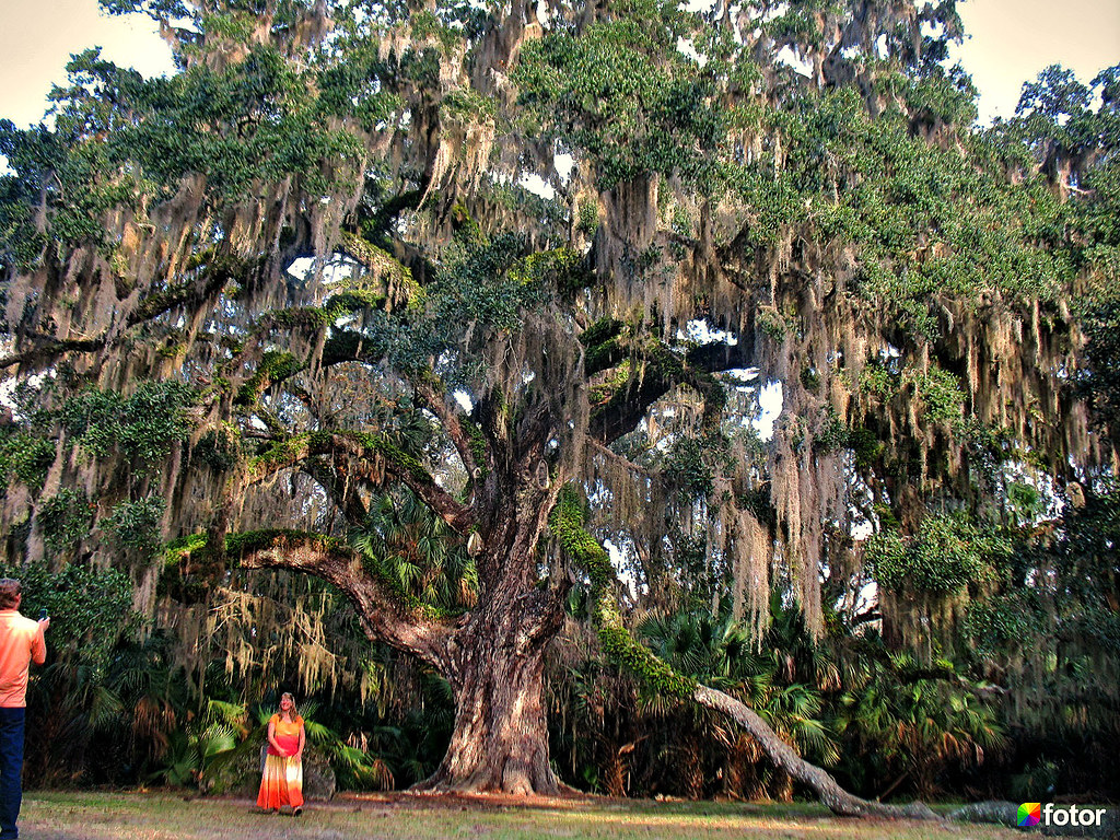
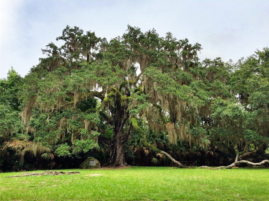
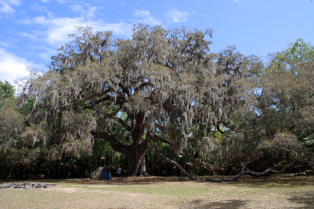
The numbers are large enough to need translation. The Fairchild Oak stands 70 feet tall. Its limbs spread 300 feet across - wider than a football field is long. Its trunk circumference measures approximately 28 feet. It is among the largest southern live oaks in the entire South, and almost certainly the most historically rooted tree on the Heritage Crossroads route.
Dendrochronological analysis places its germination at roughly 1610 CE, give or take two centuries in either direction. Work backward from that midpoint estimate and the tree was already a sapling when Spanish Franciscan missionaries were establishing their first mission chain across north Florida. Work forward and the math becomes visceral: by the time English settlers began trickling into this part of the continent, the Fairchild Oak had been growing for decades. By the time the United States existed, it had been growing for a century and a half.
The plantation connection sharpens that timeline further. Major Charles Wilhelm Bulow established Bulow Plantation on adjacent land in the 1820s. The oak, already more than 200 years old by then, stood close enough to the plantation house to have been a landmark for the enslaved workers who cleared the surrounding land for sugar cane. In January 1836, Seminole forces burned the plantation during the Second Seminole War - the ruins of which still stand today at the adjacent state historic site. The oak survived. The plantation did not.
Why did it survive? Live oaks resist fire better than most Florida trees; their bark is thick and their canopies heavy with moisture-retaining greenery. The tree also sits close to the creek corridor, where soil moisture and humidity provide insulation from surface fires. That combination of biology and microclimate has kept it standing through every subsequent century of development, drainage, and land clearing that consumed the surrounding coast.
Who Was David Fairchild?
The tree was formally named in 1955, long after it had already outlasted every human structure near it. The naming honored David Fairchild, a botanist and plant explorer whose career reshaped American agriculture and horticulture more quietly and thoroughly than almost any figure of his era.
Fairchild spent decades traveling the world in the early twentieth century collecting plants on behalf of the U.S. Department of Agriculture. He introduced mangoes, nectarines, dates, bamboo, and flowering cherries - among hundreds of other species - to North America. The Fairchild Tropical Botanic Garden in Coral Gables, Florida - founded in 1938 by Robert H. Montgomery and named in Fairchild's honor - remains one of the premier botanical research gardens in the Western Hemisphere. He was a man who understood what a living plant represents across time: not just an organism but a genetic archive, a link between what existed before and what will grow after.
That context makes the 1955 naming something more than a plaque on a fence post. Historical accounts note that parks advocate Eileen Butts championed the renaming partly to replace the negative reputation the tree had acquired under its earlier local name. Attaching the name of a world-renowned botanist to a centuries-old oak also raised its profile at a moment when Florida's coastal hammocks were being cleared at speed - a way of signaling that this was something worth keeping. The tree has carried that identity forward ever since.
The Wahlin Trail: A Freshwater Spring Hidden Behind the Giant
Most visitors who walk under the Fairchild Oak and read the interpretive sign turn around and head for the Bulow Woods trailhead. That means they miss the Wahlin Trail, which begins directly behind the oak and delivers something completely different in 0.3 miles.
The trail is a short loop. It descends into a small ravine - unusual terrain for this flat stretch of the Florida coast - where freshwater seeps from a coquina rock bluff. Coquina is a sedimentary limestone made almost entirely of compressed shell fragments, and it underlies much of coastal Florida. Where it outcrops at the surface and groundwater moves through it, the result is a slow, cold seep: not a gushing spring but a consistent trickle that feeds a miniature wetland along the base of the bluff. A boardwalk runs through this seepage zone, keeping feet dry and protecting the fragile root systems beneath.
The ecosystem inside this small ravine is noticeably different from the dry hammock above. Ferns and mosses colonize the damp rock face. The air is cooler. The light filters differently through the combination of canopy overhead and bluff to one side. Botanically it resembles the seepage bogs found much further north, pressed into a geographic anomaly here by the spring and the coquina formation behind it.
Finding the Wahlin Trail is straightforward if you know to look for it: from the Fairchild Oak interpretive sign, walk to the back side of the canopy and follow the marked path into the ravine. The trailhead is not prominently signed from the main parking area, which is why most visitors skip it entirely. The loop takes about twenty minutes to walk and is one of the most botanically interesting twenty minutes available anywhere on the southern corridor.
Hiking the Bulow Woods Trail: 6.8 Miles Between Two State Parks
Every online trail summary describes the Bulow Woods Trail as a path within Bulow Creek State Park. That description misses what makes it distinctive: it is a true point-to-point connector between two entirely separate state-managed properties, beginning at the Fairchild Oak parking area and ending at Bulow Plantation Ruins Historic State Park. Those are two different parks, administered and accessed separately. Planning the hike as a point-to-point requires a shuttle vehicle or an out-and-back commitment covering 13.6 miles total.
Trail character and terrain
The 6.8 miles run almost entirely through southern live oak hammock, one of the largest remaining continuous stands of this habitat on Florida's Atlantic coast. The terrain is flat throughout - this is coastal Florida - but the canopy provides shade across most of the route, and the trail surface alternates between packed sand, exposed roots, and occasional soft stretches through low areas. There are no significant climbs. Fitness-wise, the trail suits any hiker comfortable with a long flat walk; the main challenge is distance, not elevation.
The trail passes through the full ecological range of the park: dense hammock with a closed canopy, more open scrub edges, and at least one section close enough to the creek corridor to give views into the tidal marsh. Near the Bulow Plantation Ruins end, the understory opens slightly and the plantation-era landscape - cleared for agriculture and never fully recovered - creates a noticeably different character than the older growth sections near the Fairchild Oak.
Logistics for a point-to-point hike
- Shuttle option: Leave a second vehicle at the Bulow Plantation Ruins Historic State Park parking area (that park charges a separate entry fee - check floridastateparks.org for current rates) before driving to the Fairchild Oak trailhead to start hiking.
- Out-and-back option: Start from either end; the terrain is equally flat in both directions. Factor the full 13.6-mile round trip into your timing and water planning.
- The trail has no significant bail-out points in the middle - commit to your plan before you start.
- No water sources exist along the route; carry everything you will need for the distance.
- Start early in warm months; summer heat accumulates quickly on a long walk even under canopy.
Birding and Wildlife in the Live Oak Hammock
Bulow Creek State Park holds an official designation as a Florida Birding Trail site, and the designation is earned. More than 100 species have been recorded within the park's boundaries - a number that reflects habitat variety as much as sheer size.
Habitat-by-habitat bird guide
- Oak hammock: Spring and fall migration brings waves of warblers and vireos through the canopy. Yellow-throated, black-and-white, and prairie warblers appear during peak migration windows. The hammock's dense understory also holds resident species year-round - red-bellied woodpeckers, Carolina wrens, and blue-gray gnatcatchers are reliable at any season.
- Salt marsh edge: The tidal marsh fringing Bulow Creek produces clapper rails (heard far more often than seen), tricolored herons, and roseate spoonbills. Low tide is more productive than high tide; the exposed mudflat concentrates foraging activity. Work the marsh edge in early morning light.
- Creek corridor: Osprey are almost always visible along the main channel. Bald eagles nest in the corridor and are present year-round. Belted kingfishers patrol the banks with a loud rattle that makes them easy to locate before you see them.
Larger mammals round out the picture. White-tailed deer are common at dusk and dawn near the hammock edges. River otters appear along the creek, particularly on paddling trips. Florida black bears are recorded within the park regularly enough that food storage awareness matters on any overnight or extended visit. On warm-weather trail hikes, diamondback rattlesnakes are occasionally encountered on or near the trail surface in sunny patches. They move off when given space; watch where you step, particularly in spring and summer.
The park preserves one of the largest remaining stands of southern live oak forest on Florida's entire Atlantic coast - a habitat type that has been largely cleared for development elsewhere.Florida State Parks
Paddling Bulow Creek: The State Canoe Trail
The Bulow Creek Designated Paddling Trail runs 6.5 miles one-way from the canoe launch at Bulow Plantation Ruins Historic State Park downstream through tidal marsh to the Intracoastal Waterway at North Peninsula State Park. That is three separate state-managed properties connected by a single waterway, and it is one of the most underappreciated paddling routes on the entire Heritage Crossroads corridor.
The full route
Bulow Creek originates in Graham Swamp west of the Intracoastal and flows roughly nine miles south through tidal marsh before turning east and emptying into the Halifax River. The designated trail captures the most scenic and accessible stretch of that run. From the plantation ruins launch, the creek is narrow and canopied for the first couple of miles - live oak and cabbage palm overhang the channel, and the sense of moving through an enclosed corridor of vegetation is striking. As the creek widens toward the tidal zone, the marsh opens and the birdwatching improves: this is where roseate spoonbills and tricolored herons appear most reliably, working the shallows on an outgoing tide. The trail ends where Bulow Creek meets the Halifax River near North Peninsula State Park. Arriving at the Intracoastal after miles of tidal creek carries a specific satisfaction - the scale shifts dramatically and the open water is an unmistakable endpoint.
How to stage a one-way paddle
- Leave a takeout vehicle at the North Peninsula State Park access point on the Intracoastal side.
- Drive to Bulow Plantation Ruins Historic State Park and put in at the canoe landing.
- Check the tidal direction before launching - a falling or slack tide helps; a strong incoming tide means working against the current for the full downstream run.
- Use Walter Boardman Bridge or Smith Creek Landing as intermediate rest stops or bail-out points if conditions or timing require it.
- Complete the paddle to North Peninsula, retrieve the shuttle vehicle, and return to collect the put-in car at the plantation ruins.
Planning Your Visit
The primary access point is the Fairchild Oak parking area on Old Dixie Highway (County Road 4011), approximately five miles north of downtown Ormond Beach. The park charges no admission fee at this trailhead and is open every day of the year from 8 a.m. until sundown, with no reservation required. That combination - free, always open, no advance planning needed - is rare on this stretch of the corridor and makes Bulow Creek a natural add-on whenever plans shift or another park runs long.
Best seasons by activity
| Activity | Best season | Key consideration |
|---|---|---|
| Fairchild Oak and Wahlin Trail | Year-round | No seasonal dependency; cooler months more comfortable |
| Bulow Woods Trail hike | October - April | Summer heat and biting insects make the long flat route harder |
| Birding - migration | March - May, Sept - Oct | Peak warbler and vireo movement through the hammock |
| Birding - marsh waders | Year-round; stronger in winter | Roseate spoonbills most frequent October - March |
| Creek paddling | November - March | Lower humidity, no afternoon thunderstorms, wildlife concentrated near water |
What to bring
- Water - the Wahlin Trail and Bulow Woods Trail have no water access for their full lengths; carry more than you expect to need in Florida heat
- Insect repellent - the salt marsh edge and creek corridor carry heavy mosquito pressure from late spring through early fall
- Binoculars - the creek corridor and marsh edge reward good optics considerably; a basic pair transforms the birding experience
- Sun protection - the hammock and Wahlin boardwalk are well shaded, but the parking area and any marsh-edge sections are fully exposed
- Closed-toe shoes for any trail walking; sandals are not suitable where diamondback rattlesnakes are present seasonally
The nearest services - gas, food, and lodging - are in Ormond Beach to the south and Flagler Beach to the north. Neither is far. Cell service at the main parking area is generally sufficient for navigation and emergency use. This is not a remote wilderness park; it is an undeveloped one, which is different.
Combining Bulow Creek with the Heritage Crossroads Corridor
Bulow Creek does not stand alone on the map, and the strongest itineraries treat it as one node in a connected system rather than a single destination.
The most immediate pairing is Bulow Plantation Ruins Historic State Park, which sits at the far end of the Bulow Woods Trail. Reach it by foot (6.8 miles one-way) or by a short drive north along Old Dixie Highway. The plantation ruins - sugar mill chimney, foundation walls, the well - give historical grounding to what Bulow Creek was protecting before it was a park. The canoe launch there is also the upstream put-in for the paddling trail, so a visitor who hikes the connector trail one day and paddles the creek the next has linked four state-managed properties in a two-day sequence without ever leaving the corridor.
North to south, the Tomoka Basin cluster - Tomoka State Park and its adjacent conservation areas north of Ormond Beach - sits close enough to add as a same-day stop, particularly for birders working systematically through the corridor's hammock and estuarine habitats. The creek at Tomoka shares the same general tidal marsh and live oak character as Bulow Creek but offers more developed recreational infrastructure, with boat ramps and picnic areas that suit families or larger groups needing facilities.
For corridor travelers coming south through Flagler County, Bulow Creek functions as a natural final stop before the landscape shifts into the more urban Ormond Beach and Daytona Beach zone. The park's free admission and open hours mean there is no penalty for arriving late or staying only an hour. Pull in, stand under the Fairchild Oak, walk the Wahlin Trail, and you have seen something most Florida visitors never find - a tree older than the country it stands in, still growing.
Frequently Asked Questions
Is there a fee to enter Bulow Creek State Park?
The Fairchild Oak trailhead on Old Dixie Highway charges no admission fee and requires no reservation; it is open every day of the year from 8 a.m. until sundown. Note that Bulow Plantation Ruins Historic State Park - which serves as the far trailhead for the Bulow Woods Trail and the upstream launch for the paddling trail - is a separate property with its own entry fee. Check floridastateparks.org for current rates before combining both parks in one trip.
How do scientists estimate the Fairchild Oak's age?
Dendrochronology uses the growth rings visible in wood samples to calculate a tree's age. For living trees, researchers take narrow core samples rather than felling the tree, then count and analyze the rings under magnification. The Fairchild Oak's estimated germination date of roughly 1610 CE carries a margin of about 200 years in either direction because ring formation rates vary across centuries depending on rainfall, temperature, and soil conditions - a slower-growth period produces narrower rings that compress the apparent timeline.
Can I hike the Bulow Woods Trail as a loop and return to the same parking area?
No. The Bulow Woods Trail is strictly one-way between two different state parks with no loop option. Hiking point-to-point in either direction requires a shuttle vehicle left at the far trailhead or an out-and-back covering 13.6 miles total. There are no connecting trails or alternate routes that return a hiker to the starting parking area without retracing the same path.
What is the Wahlin Trail and how do I find it?
The Wahlin Trail is a 0.3-mile loop that begins directly behind the Fairchild Oak and descends into a ravine where freshwater seeps from a coquina rock bluff, feeding a small boardwalk-accessible wetland. To find it, walk to the back side of the Fairchild Oak's canopy - away from the parking area - and follow the marked trail into the ravine. The trailhead is not prominently signed from the parking area itself, which is why many visitors overlook it entirely.
When is the best time to see roseate spoonbills at Bulow Creek?
Roseate spoonbills are most reliably present along the salt marsh edges between October and March, when wintering populations augment the year-round resident birds. They forage actively in shallow tidal flats during a falling or low tide, which concentrates prey and makes the birds easier to observe from the creek corridor or marsh edge. Early morning offers the best combination of active birds and favorable light for seeing their pink plumage clearly.
Can I paddle Bulow Creek without doing the full one-way trip?
Yes. Walter Boardman Bridge and Smith Creek Landing serve as intermediate access points along the designated paddling trail, allowing shorter out-and-back paddles from a midpoint rather than committing to the full 6.5-mile one-way route. Paddling upstream from one of those access points and returning downstream with the current is a practical option if you have only one vehicle or limited time. Equipment rental and shuttle services are not provided by the park; check local outfitters in Ormond Beach or Flagler Beach for support.