Most Heritage Crossroads travelers stop at Princess Place Preserve, note the sign for Faver-Dykes State Park a few miles south, and keep driving. That's a mistake worth fixing. Faver-Dykes covers 1,500 acres of coastal Florida that earns the word pristine without stretching it - longleaf pine flatwoods, salt marsh, maritime hammock, and a creek designated an Outstanding Florida Water that connects this park directly to Princess Place by water. Three centuries of history run through the land: a Minorcan exile who lent his name to the creek, a general who became the first Hispanic member of Congress, a plantation that saw the Second Seminole War at close range, and a county clerk who gave it all away. Add bird species counted in the triple digits, two wilderness islands accessible only by paddle, and a trail that ends at a panoramic marsh overlook, and Faver-Dykes starts to look less like a day-stop and more like the anchor of a serious multi-day corridor trip.
Getting There and Park Essentials
Faver-Dykes State Park sits roughly 15 miles south of downtown St. Augustine. From I-95, take the US-1 exit and head south - the park entrance is a short drive down US-1, clearly signed near the interchange. The entrance road winds through scrub before opening into the hardwood hammock surrounding the campground. The boat ramp and main parking area are separate from the campground but both well marked from the main road.
The park is open daily from 8 AM to sunset. A per-vehicle entry fee covers everyone in the car; check floridastateparks.org for the current amount before you go, as fees are updated periodically. Cell service is unreliable inside the park, so download offline maps and the trail guide before arriving.
What to bring on a day visit:
- Insect repellent - mosquitoes and no-see-ums are persistent year-round near the creek and marsh edge
- Sunscreen - the Hiram Faver Trail crosses open scrub sections with no canopy
- Water - no potable water at the trailheads; fill up at the campground facilities
- Binoculars - the creek bank and Pellicer Flats overlook reward anyone who brings them
- Cash or card for canoe rentals, handled separately from the entry fee
The campground has hot showers, ADA-accessible restrooms, and a dump station. Day visitors use the picnic area and boat ramp. There is no camp store or food concession, so plan accordingly.
Three Centuries of History on One Creek
The creek running through this park carries more history per mile than most Florida waterways. Francisco Pellicer arrived in what is now Florida around 1768, part of roughly 1,403 indentured workers brought from the Mediterranean island of Minorca by British developer Dr. Andrew Turnbull. Turnbull's colony at New Smyrna was the largest British colonization attempt in the New World at that time. The reality bore little resemblance to the promise - workers faced brutal conditions, disease, and broken agreements about land and freedom.
Pellicer, born in Menorca around 1747, became one of the colony's key figures of resistance. In April 1777, he led 90 colonists on foot north to St. Augustine in the first successful mass escape from New Smyrna. The group appealed directly to the British governor, who ruled in their favor. Pellicer and many of the Minorcans who made that walk became foundational residents of colonial St. Augustine, and the creek bearing his name became a center of Minorcan homesteading in the years that followed.
The Buena Suerte Plantation
Spain regained Florida in 1783, and by 1817 the land that now forms the park had been granted by Spanish authorities to General Joseph Hernandez under the name Buena Suerte - Good Luck. Hernandez was a significant figure beyond this region: in 1822, he was elected as Florida's first territorial delegate to the U.S. Congress, making him the first person of Hispanic heritage elected to the U.S. House of Representatives.
His connection to this land deepens through the Second Seminole War, which ran from 1835 to 1842. U.S. troops occupied the Buena Suerte area during the conflict, and Hernandez commanded the force that captured the Seminole leader Osceola in 1837 - an act carried out under a flag of truce. Osceola was imprisoned and died in captivity months later. The episode remains one of the war's most debated moments, and it shadows Hernandez's otherwise substantial legacy in ways historians continue to examine.
Hiram Faver's Gift
In 1950, Hiram Faver - then serving as Clerk of the Court for St. Johns County - donated the land to the Florida State Board of Parks and Historic Memorials. The park opened the following year and carries his name. It is an unusually direct line from private ownership to public use, and the gift is why the park exists at all. The land Faver donated now sits within Pellicer Creek Aquatic Preserve, which received Outstanding Florida Water designation in 1979 - a status held by a small fraction of Florida's water bodies and one that shapes how the creek is managed today.
The Four Hiking Trails
Faver-Dykes has four trails ranging from a half-mile loop to a 2.6-mile route that delivers the park's best single view. None are strenuous, but terrain and shade vary enough that the choice matters depending on season and what you're after.
| Trail | Distance | Terrain | Shade | Highlight |
|---|---|---|---|---|
| Picnic Area Nature Trail | 0.5 mi | Flat hammock | Heavy | Mature live oak and palmetto understory |
| Campground Nature Trail | 0.5 mi | Flat, sandy | Moderate | Creek-edge access, morning bird activity |
| Pine Loop Trail | 0.8 mi | Sandy flatwoods | Partial | Longleaf pine and turkey oak scrub |
| Hiram Faver Nature Trail | 2.6 mi | Varied - flatwoods to marsh edge | Good overall | Panoramic Pellicer Flats overlook |
The short trails near the picnic area and campground are genuinely productive for birding, especially in early morning. The Campground Nature Trail edges close enough to the creek to catch wading birds at low tide, and the hammock cover keeps both short loops cooler than the open scrub trails.
The Hiram Faver Nature Trail
This is the trail to prioritize. At 2.6 miles, it moves through longleaf pine flatwoods, scrub oak, and transitional hammock before reaching the marsh edge. The payoff is a platform overlook above the Pellicer Flats, where the tidal marsh opens wide. At low tide, exposed mudflats draw a rotating cast of wading birds. At high tide, the water fills in and the light shifts dramatically - morning and late afternoon are the best windows. Bring binoculars. The trail is well-shaded for most of its length, though a mid-scrub stretch in full summer sun can be punishing after 10 AM.
Paddling Pellicer Creek: Two Directions from One Ramp
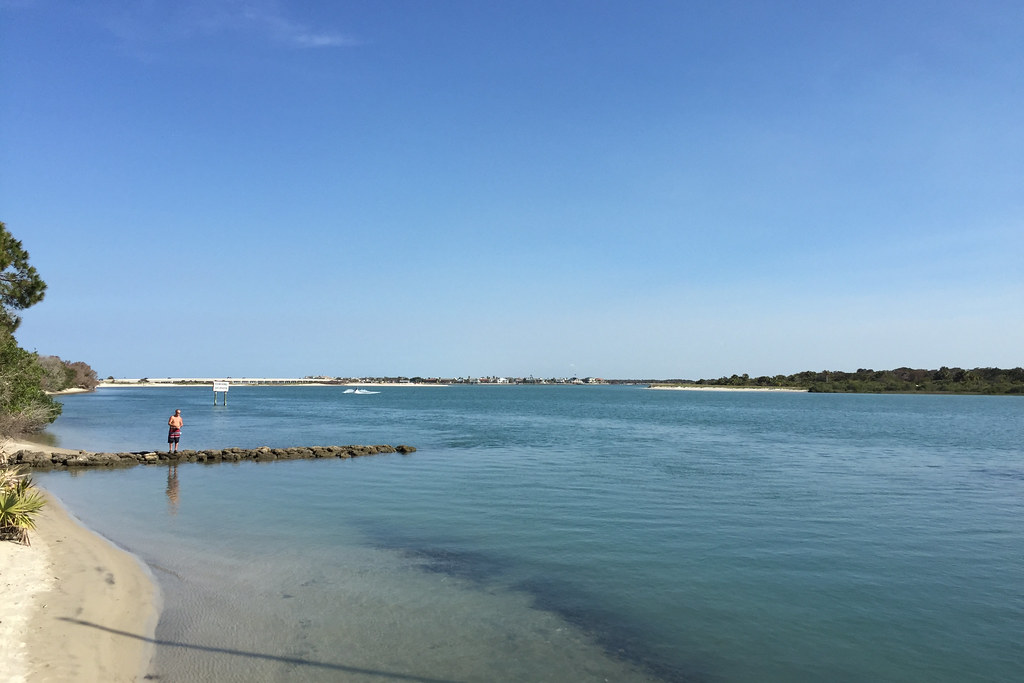
The park's boat ramp opens onto two very different paddles, and most existing guides only mention one of them. Going east takes you toward the open estuary and the Matanzas River. Going west takes you up into protected freshwater territory and - if you go far enough - to Princess Place Preserve. Understanding both directions before you launch changes how you plan the day.
Eastward: Pellicer Flats and the Matanzas River
Heading east, Pellicer Creek widens as it approaches the coast. The Pellicer Flats - the same tidal marsh visible from the Hiram Faver Trail overlook - open up before the creek meets the Matanzas River and the Intracoastal Waterway. This direction exposes you to tidal current, wind fetch, and more open water than the upstream paddle. It's better suited to paddlers who are comfortable reading conditions and monitoring tidal charts. The scenery on the flats is exceptional, and the channel through the marsh is a reliable location for wading birds and, in warmer months, manatees moving in from the Intracoastal.
Westward: Princess Place and the Freshwater Headwaters
The upstream direction is the more protected paddle and the one that most corridor visitors should plan around. Pellicer Creek narrows as it heads west, with average depths of 2 to 6 feet and a canopy that closes over the water in stretches. The creek is Segment 14 of the 1,515-mile Florida Circumnavigational Saltwater Paddling Trail - one of the longest water trails in the country - and this section ranks among its most pristine passages.
The designated trail runs 3.5 miles upstream to Princess Place Preserve, which is already a stop on the Heritage Crossroads route. Continuing to the freshwater headwaters and returning makes a 6.5-mile round trip - a solid half-day. The one-way shuttle from Faver-Dykes to Princess Place, with a vehicle waiting at the preserve, is the cleaner option for corridor visitors who want to cover ground without doubling back.
To run the one-way shuttle to Princess Place, follow this sequence:
- Before your trip, confirm Princess Place Preserve's current hours and creek access point - check the Flagler County Parks website or call ahead.
- Drop one vehicle at Princess Place's main parking area near the water access.
- Drive together back to Faver-Dykes, pay the park entry fee, and launch from the boat ramp.
- Paddle 3.5 miles northwest on Pellicer Creek, staying in the main channel and watching for trail markers where the waterway branches.
- Pull out at Princess Place, secure all gear, and drive the shuttle vehicle back to Faver-Dykes to retrieve the launch vehicle.
Canoe rentals are available at the park and include life jackets and paddles. The park does not offer kayak rentals - if you prefer a kayak, bring your own or arrange one through an outfitter in St. Augustine before arriving. Check floridastateparks.org or call the park for current rental rates, as these can change by season.
Backcountry Camping: Mellon Island and Jordan Island
Faver-Dykes offers two primitive backcountry campsites that almost no one outside the paddling community knows exist: Mellon Island and Jordan Island, both accessible only by water from the park's boat ramp. There are no facilities on either island - no restrooms, no water, no fire rings, no shade structures. What you get is creek-margin hammock, wildlife in the quiet, and a level of separation from the corridor that the developed campground cannot match.
Pack everything you need before launching:
- All drinking water for the duration - plan more than you think necessary, with no source on either island
- A portable stove - open fires may be restricted depending on conditions; confirm with park staff before your trip
- A tent with a solid rain fly - coastal hammock air is humid even when rain isn't falling
- Dry bags for sleeping gear and clothing - tipping a canoe happens, especially on a loaded run
- A downloaded offline tide chart and map - creek channels read differently in low light than in daylight
- Complete leave-no-trace kit: all waste, including food scraps, comes back out with you
Reservations for island camping run through the same system as the main campground. Contact the park directly to confirm availability and any seasonal closures - certain creek buffer areas may temporarily close during nesting periods. Island camping here is for people who genuinely want to disconnect; if paddling to your campsite with all your gear sounds exciting rather than alarming, this is one of the better-hidden opportunities on the entire Heritage Crossroads route.
Camping in the Hardwood Hammock
The developed campground at Faver-Dykes is one of the better-shaded sites on the corridor. Thirty campsites sit inside a mature hardwood hammock that keeps temperatures noticeably lower than open Florida campgrounds in summer and creates a forest quiet that settles in after day-use visitors leave. Twenty-seven of the thirty sites offer electric and water hookups, and all sites include a picnic table, grill, and fire ring. Facilities include hot showers, ADA-accessible restrooms, and a dump station.
The park limits RV length due to the hammock setting's site geometry - check the current maximum with ReserveAmerica or floridastateparks.org before booking a large rig. Reservations are made through ReserveAmerica; check there for current nightly rates and the non-refundable reservation fee that applies to each booking.
Pellicer Creek is considered one of the most pristine estuarine and riverine systems on Florida's east coast - a distinction that shapes how the park manages and protects access to the water.
Pellicer Creek Aquatic Preserve, Florida Department of Environmental Protection
The campground runs year-round, but late October through March is the most comfortable window: lower heat, reduced insects, and peak bird activity on the creek. A weekend stay built around a full corridor loop works naturally here - arrive on Friday, paddle to Princess Place on Saturday, hike the Hiram Faver Trail Sunday morning before checkout.
Birding and Wildlife by Season
Both Faver-Dykes and Princess Place Preserve hold official designations on the Great Florida Birding Trail, and the two sites function as connected habitat. The mix of longleaf pine flatwoods, freshwater transition zones, and tidal salt marsh at Faver-Dykes pulls in species at every migration stage; more than 100 migratory species have been recorded here.
Winter: November Through March
This is the most productive window. American White Pelican moves through in large flocks and is frequently visible from the Hiram Faver Trail overlook. Reddish Egret - genuinely uncommon on the East Coast - appears on the tidal flats at low water. Bald Eagle nests in the corridor and hunts the creek regularly through winter. Cold fronts push waterfowl concentration on the Pellicer Flats to numbers that reward an early morning visit.
Year-Round Residents
- Barred Owl - vocal at dusk and dawn; the campground hammock is a reliable location any time of year
- Wild Turkey - regular throughout the flatwoods and hammock edges, often encountered on the Pine Loop Trail
- Wood Stork - nests in the broader region and forages the shallows of Pellicer Creek
- Pine Warbler - a longleaf pine specialist found year-round on the Pine Loop Trail
- Brown-headed Nuthatch - another flatwoods specialist, often in mixed foraging flocks with the warbler
Wildlife Beyond Birds
American alligators are present year-round and visible on the creek bank and near the boat ramp at low tide. River otter uses the creek regularly and is sometimes spotted from a slow-moving canoe in the upstream stretch. West Indian manatees enter Pellicer Creek seasonally - typically spring through early fall - following warm water and aquatic vegetation in from the Intracoastal. Bobcat and white-tailed deer move through the flatwoods, most active at dawn and dusk on the Hiram Faver Trail.
Connecting Faver-Dykes to the Broader Corridor
Faver-Dykes is the southernmost natural anchor of the Heritage Crossroads, and it works better as a base than a checkbox. To the north by water, Princess Place Preserve is 3.5 miles upstream. The two parks share their Great Florida Birding Trail designation and function as connected habitat - paddling between them is the most direct connection on the entire corridor, no road required.
To the north by road, Fort Matanzas National Monument sits at the mouth of the Matanzas River - the same water body that Pellicer Creek flows into. The Minorcan community Francisco Pellicer helped lead to St. Augustine worshipped and settled in communities near that fort. The Old Brick Road, a surviving stretch of original King's Highway on the Heritage Crossroads, runs nearby and adds texture to the drive north.
To the south, Bulow Plantation Ruins Historic State Park and Gamble Rogers Memorial State Recreation Area extend the corridor deep into Flagler County. Both are within an hour's drive. A three-night itinerary anchored at Faver-Dykes - one day paddling north to Princess Place, one day driving south to Bulow - covers the corridor's natural and historical range without rushing a single stop.
Frequently Asked Questions
Can I paddle from Faver-Dykes to Princess Place Preserve in one day?
Yes. The route is sheltered and well-marked, and the one-way shuttle option means you can spend time at both ends without retracing the creek. See the Paddling section above for route details, tidal timing advice, and the full shuttle sequence.
Are the island campsites on Mellon Island and Jordan Island reservable in advance?
Yes - reservations are required and run through the same system as the main campground. Contact the park directly to confirm current availability; nesting activity can trigger temporary closures in creek-adjacent areas at certain times of year, so it is worth checking before you commit to a date.
What is the best time of year to visit Faver-Dykes?
October through March offers the best combination of cooler temperatures, low insect pressure, and peak bird diversity. Winter brings the largest variety of migratory species to the creek and marsh, including species that are genuinely difficult to find elsewhere on the corridor. Summer is workable but means high heat, afternoon thunderstorms, and heavier mosquito pressure - start any hike or paddle before 9 AM if that's your window.
Is the westward paddle toward Princess Place suitable for beginners?
Generally yes. The upstream creek is narrow, sheltered, and carries far less tidal current than the downstream direction toward the Matanzas. It is one of the more forgiving paddles available on the corridor for less experienced canoeists, and the scenery rewards a slower pace.
What does the Outstanding Florida Waters designation actually mean for Pellicer Creek?
Outstanding Florida Waters is a designation given by the Florida Department of Environmental Protection to water bodies with exceptional ecological, recreational, or scenic value - systems that warrant stricter protection than standard water quality rules provide. Pellicer Creek received this designation in 1979. In practical terms, it means the creek is held to a stronger anti-degradation standard than most Florida waterways, which is a significant reason the system remains as intact as it is today.