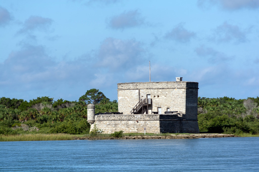
Every time you cross the Matanzas River on the Heritage Crossroads Highway - whether on the bridge near St. Augustine or at the ferry to Fort Matanzas National Monument further south - you cross water named for killing. Matanzas is Spanish for slaughters. The river and the inlet it empties into, two of the defining waterways of the northern Heritage Corridor, carry that name because of two surrender-and-execution operations conducted here in the autumn of 1565. The 18th-century watchtower at Fort Matanzas gets most of the attention, and it is worth seeing. But the fort was built 175 years after the event that named the place. The real story begins a decade earlier, with French Protestants fleeing religious persecution across the Atlantic, a Spanish captain-general racing to stop them, a hurricane that settled the military question in a single night, and a series of deaths on a sand dune that closed France's best chance at Florida for good.
France Moves First: Fort Caroline and the Huguenot Gamble
The France that sent colonists to Florida in the 1560s was a country at war with itself. French Protestants - Huguenots - faced legal persecution at home, and the prospect of a New World colony offered both distance from that violence and a chance to establish an Atlantic foothold before Spain locked down the coast entirely.
The first French reconnaissance came in 1562. Two years later, René Goulaine de Laudonnière planted a permanent settlement. On June 22, 1564, acting on the orders of King Charles IX, he established Fort Caroline on a high bluff above the St. Johns River near present-day Jacksonville. The bluff was defensible. The river offered access inland and a quick route to open water. On a map, the location looked strong.
In practice the colony was fragile from the start. The settlers were soldiers and artisans, not farmers. Food ran short. Relations with the surrounding Timucua people were essential for survival and constantly in negotiation. When Jean Ribault arrived in August 1565 with approximately 600 soldiers and 300 colonists aboard seven ships, it felt like a rescue. Fort Caroline had a real fleet, real reinforcements, and a commander with genuine military experience. The French presence in Florida had never looked stronger. It would not look that way for long.
Spain Responds: Menéndez and the Race to Florida
King Philip II of Spain viewed the French Protestant colony as a direct threat - religious, military, and strategic all at once. His response was Pedro Menéndez de Avilés, an experienced naval commander he trusted completely. Philip's orders were explicit: expel the French heretics.
Menéndez moved fast. On September 8, 1565 - while Ribault's fleet still sat at anchor near Fort Caroline - Menéndez landed at a Timucua village and formally founded St. Augustine. That date makes St. Augustine the oldest continuously occupied European settlement in the continental United States. In September 1565, it was a camp on a beach with an adversary 40 miles to the north.
Menéndez immediately planned a sea assault on Fort Caroline. Ribault, learning of the Spanish landing, sailed south to hit St. Augustine first. The two fleets came within sight of each other. Then the weather changed everything.
The Hurricane Decides
Around September 9 and 10, 1565, a hurricane struck Ribault's fleet and drove it far south of St. Augustine. Most of the ships were wrecked near present-day Cape Canaveral, roughly 150 miles down the coast. Fort Caroline was suddenly without its navy, without Ribault, and without most of its fighting men.
Menéndez saw the opening. While the storm still blew, he organized 500 soldiers and began a 40-mile overland march north through flooded terrain - rain, mud, swollen streams, coastal hammock and marsh. Modern visitors driving the Heritage Corridor in air conditioning cross this same landscape in under an hour.
The wreck of Ribault's flagship, La Trinité, was confirmed by archaeologists in 2018, found in shallow water off Cape Canaveral. French courts ruled it sovereign French property. It stands as one of the most significant colonial-era shipwreck finds in North America - the 32-gun ship that might have saved Fort Caroline, still identifiable on the Florida seafloor. That find makes the hurricane's consequence concrete in a way no document can.
![Carte tres curieuse de la Mer du Sud[...]](/img/1565-matanzas-massacres-2.jpg)
Fort Caroline Falls: The First Massacre, September 20, 1565
Menéndez reached Fort Caroline before dawn on September 20, 1565. The attack was brief. Spanish soldiers overwhelmed the undermanned garrison, killing approximately 140 French soldiers and colonists. Women, children, and those who declared themselves Catholic were spared and taken to St. Augustine. The men who could not make that claim were killed.
Menéndez renamed the fort San Mateo. He reportedly had a sign posted over the bodies of the dead.
I do this, not as to Frenchmen, but as to Lutherans.Sign attributed to Pedro Menéndez de Avilés, posted at Fort Caroline following the September 20, 1565 assault, as recorded by contemporary witnesses
The framing mattered. Menéndez was not declaring war on France - he was conducting a religious purge. That distinction shaped everything that followed at the inlet to the south, and it would echo three years later when a Frenchman came back with ships of his own and a sign of his own to post.
The Inlet as Executioner: Two Surrenders
Ribault and roughly 350 survivors from the wrecked fleet were stranded south of St. Augustine. With no ships, no fort, and no path through Spanish-held territory, they had one option: march north. They walked up the coast through what is now the Heritage Crossroads Corridor - the same thin strip of barrier island and tidal marsh the highway traces today.
They reached the Matanzas Inlet and could go no further. The water blocked them.
How the Crossings Worked
Menéndez sent a boat across. He was direct about their situation: he had already taken Fort Caroline. There was no rescue coming. Each group that surrendered was ferried across the inlet in batches of 10 to 15, hands bound behind their backs, marched behind a sand dune out of sight of those still waiting on the far shore. Those who refused to renounce Protestantism were killed by throat-cutting. Catholics and a handful of craftsmen whose skills the young colony needed were spared.
| Encounter | Date | Approximate survivors surrendered | Outcome |
|---|---|---|---|
| First surrender | September 29, 1565 | Roughly 200 men | Most executed; Catholics and skilled craftsmen spared |
| Second surrender | October 12, 1565 | Roughly 150 men including Ribault | Most executed; Ribault killed; fewer spared |
Across both encounters, historians document between 245 and 350 dead. Approximately 16 men were spared in total. Jean Ribault was executed at the second encounter on October 12. His beard was reportedly sent to Philip II as proof of his death.
A Name Pressed Into the Land
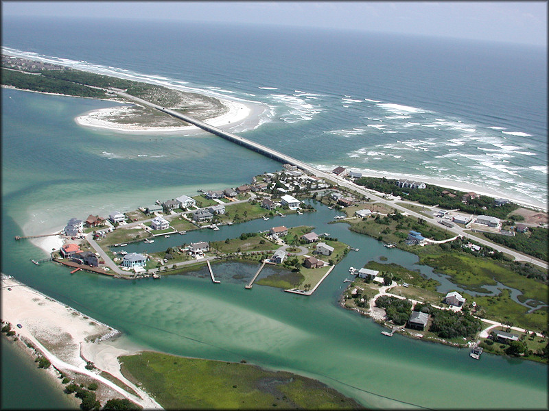
Spanish soldiers and officials who documented the autumn of 1565 called the inlet and its river by the word that described what happened there. Matanzas. The name appears on Spanish colonial maps from the years immediately after and never left. It survived the transfer of Florida to Britain in 1763, the return to Spain in 1783, and American statehood in 1845. It is on road signs today.
For Heritage Corridor visitors, the geography of the name is specific:
- The Matanzas River runs 22 miles from just south of St. Augustine to the inlet - it defines the western edge of Anastasia Island, the barrier island the corridor partly traces.
- Matanzas Inlet, at the river's southern end, is the documented site of both surrender events.
- Fort Matanzas National Monument sits at the inlet and preserves the 1740s watchtower - a structure built because the inlet's strategic importance, established in blood in 1565, was still recognized nearly two centuries on.
- The free NPS ferry crossing to the monument re-enacts, in the most peaceful possible way, the crossing Ribault's men were forced to make in the opposite direction.
The French Return: Gourgues's Revenge Expedition, 1568
France did not respond to the 1565 massacres through official channels. The French crown, Catholic itself, was in no position to protest the killing of Protestant heretics. Menéndez had handed Charles IX an excuse by framing the killings as religious rather than military. The official response was silence.
The actual response came from a private individual. Dominique de Gourgues was a French privateer who sold his personal assets and borrowed money from his brother to finance a three-ship expedition. He had no royal backing and no promise of reimbursement. He arrived off Florida in April 1568 with a single target: Fort San Mateo, the Spanish garrison occupying what had been Fort Caroline.
De Gourgues allied with Timucua Chief Saturiwa - one of the most powerful Indigenous leaders in northeastern Florida. Saturiwa had his own grievances against Spanish occupation; the Spanish presence had disrupted Timucua political networks and trade relationships that predated any European contact. The alliance was practical on both sides.
- De Gourgues landed his forces and made contact with Saturiwa's warriors.
- Combined French and Timucua forces moved on the Spanish positions around Fort San Mateo.
- The Spanish garrison was captured after a short fight.
- De Gourgues burned the fort.
- He hanged his Spanish prisoners from the same trees Menéndez had reportedly used three years earlier.
- He posted a sign: Not as to Spaniards or as to mariners, but as to traitors, robbers and murderers.
Then he sailed back to France - and received a cold reception. The Catholic king refused to reward him. De Gourgues faced temporary exile to avoid arrest. He had avenged French Protestants at personal financial ruin and was treated as a liability for doing it. The symmetry of his sign and Menéndez's sign was perfect. The symmetry of their treatment by their respective crowns was not.
Legacy: What the Massacres Built and Destroyed
The events of 1565 did not just end French colonization of Florida. They determined the shape of everything the Heritage Crossroads Corridor preserves today. Spain controlled Florida after 1565 - with one British interruption from 1763 to 1783 - for roughly two centuries. Every colonial-era site on the Heritage Corridor exists within that timeline:
- The Castillo de San Marcos in St. Augustine, begun in 1672, is the direct institutional descendant of the fortifications Menéndez started on September 8, 1565.
- The Franciscan mission system that spread through Timucua territory in the late 16th and 17th centuries exists because Spain held Florida, not France. Mission ruins and archaeological sites through Flagler and Volusia counties mark that spread.
- The land grant system that created the plantation corridor visible in the Heritage Corridor's Flagler County section developed under Spanish governance shaped by the post-1565 occupation.
The Timucua Price
The Timucua paid the steepest cost. Saturiwa and his people had been caught between two colonial powers from the beginning - trading with Laudonnière's French settlers while managing Spanish incursions from the south. The Spanish occupation after 1565 brought sustained mission pressure, forced labor systems, and eventually epidemic disease on a scale no political alliance could absorb. The Timucua population collapsed over the following century. By the time Britain took Florida in 1763, the Timucua as a distinct society had effectively ceased to exist. The ally de Gourgues found in 1568 was already on the path to erasure that the 1565 events helped accelerate.
None of this was inevitable. Had Ribault's fleet not met the hurricane on September 9, the military balance shifts. The Heritage Corridor would carry different names, different colonial architecture, different mission routes. The 1565 massacres are not a footnote to Florida history. They are its hinge - and the river that runs through this corridor says so every time you read the sign.
Frequently Asked Questions
What does Matanzas actually mean?
The word is Spanish for slaughters or killings, applied to the inlet and river immediately after the 1565 events. What is worth noting is that it stayed. Spanish colonial officials promoting settlement had no obvious reason to keep a name advertising mass killing at a strategic waterway. The name held anyway - through British governance, the return to Spain, and American statehood. Most colonial-era place names from this period were changed during those transitions or dropped from common use. Matanzas was not. A name that could have been quietly revised after each change of sovereignty is still on road signs more than 450 years after the event that created it.
Is Fort Matanzas National Monument the actual site of the 1565 killings?
The 'Before you start' callout above covers the timeline: the watchtower dates to the 1740s, not 1565. A separate question is what physical evidence of the 1565 events actually survives at the inlet. The answer is none. No earthworks, markers, or structures from that year remain. What the monument preserves is the geography: the same inlet, the same tidal barrier that stopped Ribault's survivors from crossing on foot, the same relationship between open water and barrier island that made this a chokepoint. The inlet's strategic value did not change between 1565 and the 1740s - that unchanged geography is why a fort eventually went there. The monument marks where an event happened, not a structure left by it.
Why didn't France officially respond to the 1565 massacres?
The French crown under Charles IX was Catholic. Menéndez explicitly framed the killings as religious action against Lutherans rather than military action against French subjects - which gave the crown an excuse to stay quiet without admitting weakness. Protesting the massacre meant defending Huguenots at home, which was politically untenable. Dominique de Gourgues filled the vacuum through private means in 1568, and even his successful revenge expedition earned him royal cold-shouldering rather than recognition.
What happened to the Spanish Fort San Mateo after de Gourgues burned it?
Fort San Mateo - the renamed Fort Caroline - was destroyed by de Gourgues in 1568 and never rebuilt in the same form. Spain's colonial focus in Florida shifted south to St. Augustine, which became the durable center of Spanish power in the region. The St. Johns River bluff where Laudonnière had built his colony reverted to wilderness, and the institutional energy that might have sustained a northern outpost went instead into the Castillo and the mission network spreading through Timucua territory.
What is the connection between the Timucua people and these events?
The 'Timucua Price' subsection covers the long-term outcome. The detail worth adding is what Saturiwa's 1568 alliance with de Gourgues reveals about Timucua decision-making during the conflict itself. Saturiwa allied with de Gourgues not out of sympathy for French Protestants but because Spanish occupation had broken the political networks and trade relationships through which Timucua power operated before any European arrived. De Gourgues offered a chance to reverse that, and Saturiwa took it. The calculation was reasonable. The problem was that the reversal did not hold - Spanish presence returned and intensified, and the Timucua absorbed the consequences. Reading Saturiwa as a political actor pursuing Timucua interests, rather than as a supporting figure in a French-Spanish dispute, changes how the entire 1568 expedition reads.
What is the La Trinité shipwreck and why does it matter to Heritage Corridor visitors?
The 2018 identification and its historical significance are covered in 'The Hurricane Decides' section above. For visitors on the corridor route, the practical point is this: the wreck lies roughly 150 miles south of the corridor, off Cape Canaveral, and is not a public destination. Its value to corridor visitors is not as a place to go but as confirmation of something abstract. Before 2018, the hurricane existed in Spanish and French accounts but had no physical location. The confirmed wreck gives the storm a fixed point on a map - a specific spot where the military force Ribault needed to reach Fort Caroline ended on the seafloor. The Heritage Corridor traces a coastline whose character was determined partly by that storm. Knowing the wreck is confirmed and located gives that fact weight that historical records alone do not.