The Halifax River runs for roughly 25 miles through northeastern Volusia County, tucked between the Atlantic barrier island and the Florida mainland in a narrow tidal corridor that rarely exceeds 5 feet in depth. That shallowness is the first thing to understand about the river - it is not a dramatic waterway but a working one, historically used for transportation, plantation commerce, and resort access, and now protected as a federal manatee nursery. Four state parks, two plantation ruins, the city of Ormond Beach, and the winter estates of two Standard Oil co-founders all sit directly on its banks or on its tributary creeks. Following the Halifax from its origin at Tomoka Bay to its Atlantic outlet at Ponce de Leon Inlet means following the entire Volusia County segment of the heritage corridor in a single continuous line.
Geography: ICW Spine from Tomoka Bay to Ponce Inlet
The Halifax takes shape at Tomoka Bay, where the Tomoka River, Bulow Creek, and Halifax Creek converge at the northern edge of Tomoka State Park. That three-way confluence creates one of the most productive brackish mixing zones on Florida's northeast coast - freshwater draining from the Volusia County interior meets saltwater pushed inland by tidal exchange, producing conditions that support an outsized range of marine life and that drew human settlement for centuries before the first European surveyors arrived.
At its southern end the river merges with Spruce Creek before connecting to the Atlantic through Ponce de Leon Inlet, the same cut of water that separates Daytona Beach's barrier island from the New Smyrna Beach peninsula. Between those two endpoints, the Halifax functions as a continuous segment of the Atlantic Intracoastal Waterway - the sheltered inside passage running the length of the East Coast. Its drainage basin covers most of eastern Volusia County. Pleasure boats, sailboats, and commercial vessels transiting the full ICW route from Maine to Key West pass through the Halifax as a matter of course.
That ICW designation shapes the visitor experience in practical ways. The river carries channel markers, federally maintained navigation aids, and a steady flow of transiting vessel traffic. It is not a wilderness paddling corridor from bank to bank - it is an active navigational channel with a wilderness paddling corridor running alongside it, depending on which section of the river you choose.
From North Mosquito River to Halifax: A Name Stretched Across Two Continents
Under Spanish colonial administration the waterway carried the name North Mosquito River - the northern branch of a broader estuarine system whose southern section extended down into what is now the Indian River Lagoon. The name was workmanlike and geographic, not particularly flattering to the territory it described.
Britain's victory in the Seven Years' War ended the Spanish period in 1763. The Treaty of Paris transferred East Florida to the Crown, and new colonial administrators began renaming the land to signal possession. The estuarine system was split at its principal inlet: the northern section became the Halifax, the southern section became the Indian River, and the North Mosquito River name disappeared entirely.
The Secretary of State Who Named a River
The Halifax River takes its name from George Montagu-Dunk, 2nd Earl of Halifax, who lived from 1716 to 1771. He served as Secretary of State for the Southern Department from September 1763 through July 1765 - the specific cabinet position responsible for governing Britain's newly acquired colonies in the American South, including East Florida. Colonial surveyors and administrators operating in a new territory named geographic features after the minister who held authority over both their careers and their colony's future; the Earl of Halifax was that minister.
What makes the naming historically interesting is that Halifax had already lent his title to a settlement in Atlantic Canada fourteen years earlier - Halifax, Nova Scotia was founded in 1749 when the earl was instrumental in promoting British colonial settlement there. The Florida river's naming in 1763 extended that legacy across a second continent. One minister's title now marked a harbor in Canada and a tidal estuary in Florida, fourteen years and roughly 1,500 miles apart. No other page on the web connects the administrative mechanics of that transatlantic naming - the specific role the earl held, the precise window of his tenure, and the fact that he had already given his name to Nova Scotia long before Florida came into the picture.
The Timucua on the Halifax
The Tomoka Bay confluence was a significant settlement site for the Timucua people long before European surveyors gave the river any name. Archaeological evidence recovered at and near Tomoka State Park - shell middens, ceramic fragments, and the elevated hammock ridges that characterize Timucua habitation sites - confirms occupation across an extended period. Spanish records from the colonial mission period provide some of the earliest written documentation of villages near the confluence, though those records describe a population already in decline from disease and disruption brought by earlier contact.
The Timucua were not a single unified tribe but a language group whose territory covered much of northern Florida. Villages along the Halifax relied on the river's fish and shellfish, used its tidal creek network for travel between settlements, and occupied the high ground along the western bank that offered protection from flooding. The same ecological factors that made the northern Halifax attractive to 19th-century resort developers - sheltered water, abundant fish, stable elevated land just back from the bank - had organized Timucua settlement for generations.
Britain's 1763 acquisition came after Spanish missionaries had already spent a century working through the region. By the time colonial surveyors were naming the river for the Earl of Halifax, the Timucua population had been reduced to a fraction of its pre-contact numbers. Almost no above-ground Timucua-era structures survive. The site at Tomoka State Park preserves buried evidence under protected ground, and the nature trail there interprets what excavation has shown.
Colonial Grants and the Founding of Two Towns
British land grants along the Halifax encouraged plantation development during Britain's short control of the territory, which lasted from 1763 to 1783 before Spain reclaimed Florida. Most of those estates were abandoned when the Spanish period resumed. Settlement along the Halifax restarted under the second Spanish period and continued after American acquisition in 1821.
James Ormond arrived on the Halifax in 1807 on a Spanish land grant, establishing a plantation on the river's west bank. The town that eventually grew near his landholding carries his name: Ormond Beach, still the city directly north of Daytona Beach on the heritage corridor route.
Further south, the character of Halifax settlement shifted from plantation agriculture to deliberate town-building. Mathias Day, originally from Mansfield, Ohio, purchased Halifax River frontage in 1870 and platted the settlement he named after himself - the community that became Daytona Beach. Day's purchase defined the urban geography of the Halifax's most developed stretch.
The first bridge crossing the Halifax opened in 1887, connecting the Ormond Beach mainland to its barrier island. That crossing marked a shift: the river was no longer simply a transportation corridor and plantation boundary but a threshold to be overcome on the way to the ocean-facing coast. The bridge it was eventually replaced by - the Granada Bridge, which still carries State Road 40 across the Halifax today - remains the most recognizable span on the waterway.
The Gilded Age Halifax: Standard Oil Winters on the West Bank
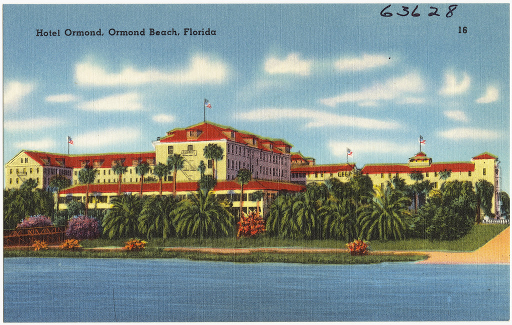
John Anderson and Joseph Price opened the Ormond Hotel on the Halifax's west bank on January 1, 1888. The hotel faced the river and offered a level of service aimed at northern tourists who had money and the winter months to spend in Florida's warmth.
Henry Flagler, the Standard Oil co-founder whose Florida East Coast Railway was then reshaping the state's east coast, purchased the hotel in 1890. Under Flagler's ownership the property expanded substantially - eventually reaching some 400 rooms spread across a property stretching from the Halifax bank east to the Atlantic Ocean. The Ormond Hotel became an anchor of the Florida winter season for the northern wealthy class, drawing the kind of guests who expected resort amenities scaled to serious wealth.
John D. Rockefeller, Flagler's former business partner at Standard Oil, first stayed at the Ormond Hotel in 1914. He found the river setting agreeable enough that he purchased The Casements estate on the Halifax bank as his permanent winter home, returning each year until his death in May 1937. Two men who had built Standard Oil into one of the most powerful commercial enterprises in American history both spent their winters within view of the same shallow tidal river in Ormond Beach, Florida.
The Halifax River waterfront between Ormond Beach and Daytona Beach holds a denser concentration of Gilded Age American wealth history per river mile than almost any other estuary on the East Coast - two Standard Oil fortunes, one transformative railroad developer, and the first automotive racing beach, all organized around a brackish tidal river running between a narrow barrier island and the Florida mainland.
The Casements still stands on the Halifax bank in Ormond Beach and operates today as a cultural center and museum. The Ormond Hotel is gone, but its riverfront setting and the Granada Bridge crossing it faced are still there.
The 2003 Federal Manatee Refuge: What the Mortality Data Showed
The U.S. Fish and Wildlife Service's decision to designate the Halifax and Tomoka Rivers as a federal manatee refuge in September 2003 rested on documented mortality data, not precautionary reasoning alone. Researchers had recovered 16 manatee carcasses attributed to watercraft strikes from the Halifax River specifically. The FWS classified the entire Tomoka-Halifax system as a highly-used birthing and calving area for West Indian manatees - meaning adult females were returning to the river to give birth, so every boat-strike death was compounded by the loss of a calf or the disruption of a reproductive cycle.
The refuge, with its designation published in the Federal Register in 2003, covers approximately 36 miles of Volusia County waterways and imposes year-round speed restrictions. This matters for every motorized vessel operator on the river: the refuge does not follow a seasonal calendar that opens in summer. Manatees use the Halifax year-round, and the speed restrictions run year-round with them.
For non-motorized visitors the designation works in their favor. Suppressed boat speeds across the full river corridor make kayak, canoe, and paddleboard travel noticeably quieter and safer than it would be on an unregulated stretch of the ICW. Manatees are present in the Halifax throughout the year; sightings are most concentrated from October through March, when cooler water temperatures drive them toward warmer shallow-water areas.
Fishing the Halifax River
The Halifax's brackish, grass-flat-rich environment supports a genuinely varied inshore fishery. Ten species regularly sought by anglers inhabit its waters:
- Redfish - present year-round along grass flats and oyster bars throughout the river
- Spotted sea trout - most active in cooler months, favor shallow grass edges near the channel margins
- Snook - peak activity in summer and fall; concentrate near bridge pilings, dock structures, and tidal creek mouths
- Flounder - bottom species found near tidal creek entrances and grass-to-sand transition zones
- Tarpon - migratory, present late spring through early fall; often visible rolling near the surface in the deeper sections
- Black drum - winter months; look for them near oyster bars and dock pilings in the northern river
- Sheepshead - winter and spring around hard structure; notorious for stealing bait without getting hooked
- Mangrove snapper - structure-oriented, present throughout warmer months near docks and bridge shadow
- Pompano - spring and fall migration runs along the lower Halifax, often in the flats near the inlet end
- Spanish mackerel - faster water near Ponce Inlet, most reliable during spring and fall migrations
Public fishing access begins at Tomoka State Park, where bank fishing and kayak-launched fishing both work around the confluence area. Moving south, the Ormond Beach waterfront offers multiple shoreline spots and causeway access. Daytona Beach's waterfront piers and causeways provide the most concentrated public access on the river. Florida classifies the Halifax as saltwater for fishing license purposes - check myFWC.com for current saltwater license requirements before fishing from shore or a vessel. When evaluating charter operators, look specifically for captains who work the river inshore rather than offering Halifax access as an afterthought to offshore fishing; the two fisheries call for different equipment, tide knowledge, and access points.
Paddling and Wildlife Watching
The Halifax's shallow depth and protected position make it well-suited for kayak and canoe use across most of its length, though conditions vary considerably by segment. The comparison below reflects what each stretch of the river actually offers a paddler or wildlife watcher:
| Segment | Character | Primary Wildlife | Paddling Difficulty |
|---|---|---|---|
| Tomoka Bay - northern Halifax | Undeveloped, mangrove-fringed, minimal boat traffic | Manatees, osprey, wading birds, dolphin | Low - calm and sheltered |
| Ormond Beach waterfront | Transitional - riverside parks, some ICW traffic | Dolphin, pelicans, mullet schools, occasional manatee | Low to moderate - watch ICW vessels |
| Daytona Beach central | Urban waterfront, marinas, piers | Dolphin, seabirds, structure fish visible from docks | Moderate - higher vessel traffic density |
| Southern Halifax near Ponce Inlet | Wider, exposed, tidal current increases | Shorebirds, pelicans, tarpon near inlet mouth | Moderate to high - tidal flow and wind exposure |
The Halifax River Trail, a paved multi-use path running along the Daytona Beach and Ormond Beach waterfronts, is a designated segment of the East Coast Greenway - the 3,000-mile trail corridor from Maine to Key West. Cyclists and walkers following the trail get continuous river views without navigating ICW traffic, and the greenway designation connects the Halifax waterfront to mapped routes extending well beyond Volusia County.
Three practices consistently improve wildlife sightings from shore or water:
- Arrive at or before first light - dolphin and wading bird activity peaks in the two hours after sunrise when baitfish move through the shallows and boat traffic is minimal
- Watch for manatee noses, not full bodies - the most common sighting is a rounded snout breaking the surface for a breath followed by a slow submerge, usually near grass flats or in the calm water alongside a dock or seawall
- During cold snaps from November through February, manatees concentrate near warm-water sources - power plant outfalls and spring-fed creek inflows are the most reliable cold-weather aggregation points in the Halifax system
Practical Visitor Guide
Best Times on the River
Late October through April combines favorable weather, peak manatee visibility, and the most productive inshore fishing on the Halifax. Summer is fully viable but brings afternoon thunderstorms and heat; manatee sightings in summer are more dispersed across the river system than in winter when they concentrate near warm-water refuges. Spring and fall are the best seasons for migratory fish species - tarpon in late spring, pompano and Spanish mackerel during both migration windows.
Access Points and Launches
Tomoka State Park provides a boat ramp and kayak launch at the river's northern end - the best single access point for anyone who wants the full northern river experience. Ormond Beach's riverfront parks provide hand-carry launches and shore fishing access along the central corridor. Daytona Beach's waterfront offers public boat ramps and causeway access with ample parking. Check floridastateparks.org for current launch fees and hours at Tomoka and other state-managed sites; fees change periodically and the official site carries current figures.
Connecting the Halifax to the Heritage Corridor
The river works best as a connective thread through a multi-stop itinerary rather than a standalone destination. A logical sequence:
- Start at Tomoka State Park - take the nature trail to the Timucua midden site, then launch kayaks from the state park ramp to see the northern river's confluence where the Halifax begins
- Drive south on Old Dixie Highway to the Ormond Beach waterfront and walk the riverside section of the Halifax River Trail past the Granada Bridge and the site of the former Ormond Hotel
- Visit The Casements on the river's edge in Ormond Beach - Rockefeller's former winter home offers the Halifax river view that drew him back every winter for more than two decades
- Continue south into Daytona Beach to the main waterfront piers and causeway access points along the Halifax's most urbanized stretch
- End at or near Ponce Inlet to see the river's southern terminus where the Halifax meets the Atlantic - a geographic endpoint that also anchors the ICW's passage through the entire county
Several sites within the broader heritage corridor connect directly to the Halifax through its tributary system:
- Bulow Creek State Park - covers the creek that feeds Tomoka Bay, linking Halifax River paddlers to the plantation-era Bulow Sugar Mill Ruins further north on the corridor
- The Casements (Ormond Beach) - Halifax riverfront estate with interpretive rooms and riverside grounds open to visitors
- Tomoka State Park campground - allows multi-day stays for visitors wanting more than a day's access to the northern river
Frequently Asked Questions
Is the Halifax River saltwater or freshwater?
The Halifax is a brackish tidal estuary - its salinity varies by location and season, but it connects to the Atlantic Ocean through Ponce de Leon Inlet and receives saltwater tidal exchange throughout its length. Florida classifies it as saltwater for fishing license purposes, so a Florida saltwater fishing license is required for fishing from its banks or from a vessel. Check myFWC.com for current license requirements, as specific rules and categories change over time.
Can you paddle a kayak the full length of the Halifax?
The full river is navigable by kayak or canoe, but roughly 25 miles makes a one-day through-paddle unrealistic for most people. The more practical approach is to choose a segment - the Tomoka Bay confluence area in the north offers the most intact natural character; the Ormond Beach waterfront section offers history and shoreline amenities; the southern Halifax near Ponce Inlet brings stronger tidal current and wind exposure that requires more experience and attention to conditions. Shuttle logistics between launch and takeout need planning, as the river runs one direction and the road distance for a vehicle shuttle is significant.
When is the best time to see manatees in the Halifax?
Manatees are present year-round because of the federal refuge designation, but the most concentrated sightings occur between October and March when falling water temperatures push them toward warmer, shallower areas. Early morning in that window offers the best conditions: calm water surface makes the breathing ripples and nose-breaks easier to spot, and boat traffic is lighter. The Tomoka Bay area and the northern river consistently produce the highest sighting frequency. During cold snaps, any warm-water discharge point in the system becomes a reliable aggregation site.
How did a river in Florida get the same name as Halifax, Nova Scotia?
Both were named for George Montagu-Dunk, 2nd Earl of Halifax. Halifax, Nova Scotia was named in 1749 when the earl was influential in promoting British colonial settlement in Atlantic Canada. The Florida river was named fourteen years later, after the 1763 Treaty of Paris brought East Florida under British control and colonial administrators named geographic features after the minister responsible for governing the new territory. The earl held the specific role - Secretary of State for the Southern Department from late 1763 through mid-1765 - that made East Florida his administrative charge, and his name went onto the colony's main waterway accordingly. The same title now marks a major Canadian port city and a Florida tidal estuary, with an ocean between them.
What does the manatee refuge designation actually prohibit on the Halifax?
The Halifax and Tomoka Rivers Manatee Refuge, effective since September 2003, imposes year-round speed restrictions on motorized vessels within the refuge boundaries. Speed zones vary by location - some areas require idle speed, others slow speed - and those restrictions apply continuously, not just in cold months. The refuge does not prohibit fishing, non-motorized paddling, anchoring, or other non-motorized activities. For the current zone map and boundary coordinates, consult fws.gov or the Florida Fish and Wildlife Conservation Commission boating safety resources before launching a motorized vessel anywhere on the Halifax.
Is the Halifax River part of the Intracoastal Waterway?
Yes - the Halifax functions as a continuous segment of the Atlantic Intracoastal Waterway through Volusia County, running from Tomoka Bay in the north to Ponce de Leon Inlet in the south. That ICW designation means the river carries both recreational and commercial transiting vessel traffic following a marked navigation channel, and federal navigation rules apply throughout. For paddlers this means being aware of which water is the marked ICW channel and understanding that sailboats and larger vessels transiting the full East Coast passage move through the Halifax as part of their route, not as local traffic.